Unicycle Weekend
September 17–19, Lake Tahoe
|
|
|
|
|
|
|
|
|
|
|
|
|
|
|
|
|
|
|
|
|
|
|
|
|
|
|
|
Saturday Activities
Location:
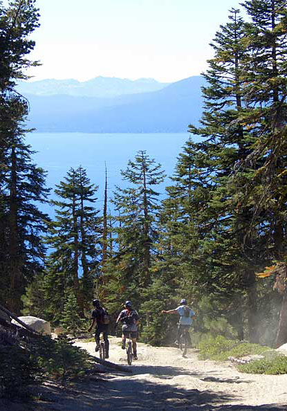
The Tahoe Rim Trail
from Mt. Rose Highway to Tunnel Creek. This is an 11-12 mile ride at high
altitude. You will be up around 9000 feet, so keep this in mind when judging
your ability to ride the distance. There is not a lot of climbing on the ride,
with the main uphill section in the first mile or so. This is probably less
than 500 feet, so anyone can walk it if they can't ride it.
This ride is surrounded by beautiful scenery, so we are not suggesting a different trail as an alternate ride. People wanting a shorter ride can go in the first few miles, then turn around when they feel it's time. We will stop and group up, so there will be appropriate places to do this. I would like to keep a count of riders on the trail as well, so we want to know who turns around.
You will see spectacular views, not only of Lake Tahoe (like on the famous Flume Trail), but of the Washoe Valley on the Nevada side. The trail is littered with rock gardens and technical challenges along the way. The fast riders will not be bored waiting for the main group because there is plenty to play on. Photo opportunities galore.
Start
time:
Probably 10:00 am at the trailhead along Mt. Rose Highway. Final time TBA.
This will give us plenty of time to ride and play.
Be prepared:
You will be riding in a wilderness area, with no water and no services. Put
on some sunscreen. The high altitude makes it easier to burn. Bring your pads,
helmet, and tools. Nothing like being stuck out there without that little
5/16" allen wrench your frame's maker decided to make you carry. If you
break things a lot, bring some tape. It may be chilly in the morning, but
should warm up real nice. When we rode the trail on Sept. 4, we were fine
with T-shirts.
Getting there:
See this page for directions.
Lunch:
Bring it. You are on your own up there! We will stop somewhere near some big
rocks where we can watch people hop around while eating.
End of the trail:
The ride finishes with several miles of downhill along Tunnel Creek Road (a
sandy jeep road). This is the same exit as the Flume Trail for those of you
that came in 2000. This is upwards of 3000' of downhill riding in a relatively
short distance, so use brakes if you got 'em. When you get almost all the
way down to Lake Tahoe, the trail will split right and left. Go to your right
(around a gate) toward the Ponderosa Ranch. This route should bring you right
out into their parking lot, where we will wait for our pickup rides.
Dinner:
Unknown. We will probably split up so we don't overwhelm any local restaurants,
or eat in at the cabins. We will try to set up a video night either Friday
or Saturday, at whichever cabin or home has the best TV-watching situation.
Top of Page
Legal stuff. Copyright © 2004, John Foss