| Technical Level: | Beginner Plus |
| Strenuous Level: | Intermediate (just because its long and hot) |
| Altitude Gain: | Minimal -- Up and Down a lot, but no major altitude change |
| The Ride: | 10 miles one way, 20 miles round trip Mostly wide single track |
| Where: | Salmon Falls Road north east of Folsom. |
| When: | All year, but its really hot in the summer |
From Sacramento: Take Highway 50 East towards Lake Tahoe to Folsom
Blvd. Head North East on Folsom Blvd. towards Folsom for about a
mile. Turn Right (East) on Blue Ravine Road. Continue on Blue
Ravine several miles to Salmon Falls Road in Eldorado Hills (Note that
Blue Ravine turns into GreenValley road at the Albertson's shopping center).
Salmon Falls road is the first left after Fransisco Road. Take Salmon
Falls road about 5 miles to the American River. You will pass a sign
on your left pointing to the Folsom Lake SRA, and immediately after this
sign, you will see the bridge crossing the south fork of the American River.
Just before the bridge on the left is free parking in the dirt. There
are 3 paved parking lots near the bridge but they cost $2. Park that
4 wheeled beast, and get out the bi-wheeled destroyer. Cross the
bridge, the trail head is on the left hand side of the road on the North
West Side of the bridge. Just after crossing the bridge, there is
a paved parking lot on the left hand side (North West side). At the
end of the parking lot closer to the bridge is the Salmon Falls Trail Head.
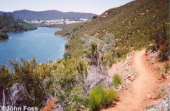
 The
Trail follows Folsom Lake and ends up in Peninsula Park. At the very
beginning there are several turns, but they all quickly rejoin. The
first few miles are treacherous!! There are big drop offs, and it
is pretty strenuous, but it gets easier! There are lots of possible
courses on this trail, but they all end up in the same place (except the
4 way intersection described below). Several miles into the trail,
you will ride down into a small valley on nasty rutted fire road and cross
a small creek (that may or may not have water in it). You will ride
across a small open plane and then the trail will Y. Both directions
rejoin in a few miles, but you wouldn't know that unless I told you!
Try one direction on the way and the other on the way back.
The
Trail follows Folsom Lake and ends up in Peninsula Park. At the very
beginning there are several turns, but they all quickly rejoin. The
first few miles are treacherous!! There are big drop offs, and it
is pretty strenuous, but it gets easier! There are lots of possible
courses on this trail, but they all end up in the same place (except the
4 way intersection described below). Several miles into the trail,
you will ride down into a small valley on nasty rutted fire road and cross
a small creek (that may or may not have water in it). You will ride
across a small open plane and then the trail will Y. Both directions
rejoin in a few miles, but you wouldn't know that unless I told you!
Try one direction on the way and the other on the way back.
Critical Turns:
At the very end of the trial, there is a 4 way marked intersection
on fire road. Go straight through this intersection towards Peninsula
Park. In about a mile you will come out on a paved road. Turn
right and stay on this road, you're now in Peninsula Park. In a half
mile or so, there is a really nice grassy area with some trees and water.
Take a break and get ready to head back!! All the other turns on
this trail are either marked or obvious. You won't have any trouble!